|
|
Ridges and peaks of the Ukrainian Carpathians
 The Ukrainian Carpathians are situated on the territory of Transcarpathian, Lviv, Ivano-Frankivsk and Chernivtsi Regions and cover the area of 24 thous. sq.km. The length from the Upper Sian to the issue of the Suchava accounts for 280 km, the width is about 100 km.
The absolute heights of the mountain system change from 120-400 m near the foothills to 500-800 m in the intermontane ravines and 1500-2000 m along the main ranges.
The Carpathian lowland and mountain parts are represented by the mountain massifs of the Eastern Beskydy, Horhany and Pokutsko-Bukovynsky Carpathians. Lowlands and ravines of the Vododilna-Verkhovynska area form the central zone of the mountains. Behind them there is an orographic core of the Polonyno-Chornohorsky Carpathians that include the highest peak of the Ukrainian Carpathians - Mt. Hoverla (2061m). Next to the southern west the ancient Rakhivsko-Chyvchynskyi crystal massif has been preserved.
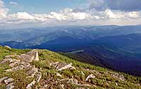 The round-shaped peaks and wide ridges are covered with sub-alpine and alpine meadows which are called "polonyny". The ancient mountains are covered with piny brushwood. Lower - the kingdom of forests. Not without reason the Ukrainian Carpathians are called wooded. First there is a wide zone of fir and spruce woods. Closer to the valleys' bottoms the steep slopes are occupied by the powerful beech forests on the brown mountain-forest rocky soils. The considerable oak woods have been preserved in the southern pre-mountain zone. From the upper bounds of forests to the foot grasslands can be found. On the hills and plains the gardens, arable lands, vineyards predominate.
The highest peaks of the Ukrainian Carpathians are located in the Chornogora massif:
Hoverla, 2061 m
It is situated on the border of Ivano-Frankivsk and Transcarpathian regions. Cone-shaped. Covered with alpine meadows, brushwood. Near the foothills - one of the Prut source, waterfall.
Brebeneskul, 2032 m
It is situated on the border of Ivano-Frankivsk and Transcarpathian Regions. Round-shaped. Covered with alpine and sub-alpine flora. Rock placers and are typical.
Pip-Ivan, 2022 m
It is situated on the southeastern ridge's edge on the border of Ivano-Frankivsk and Transcarpathian regions. Pyramidal-shaped. Covered with sub-alpine flora. Brushwood and fir forests are widespread. The name is connected with the rock on the peak that is similar to a priest in the cassock. On the top there are remains of the Polish observatory of the beginning of the 20th century.
Petros, 2020m
It is situated on the northern-west range's part between Mt. Shehul and Mt. Hoverla in Transcarpathian region. The western and southwestern slopes are steep with numerous rock placers, northern and northeastern slopes are abrupt with the rocky ledges. Covered with sub-alpine flora. Brushwood and fir forests are widespread.
Hutyn-Tomnatyk, 2016 m
It is situated on the southern spurs of the Chornohora main range within Transcarpathian region. Near the northeastern foot there is Lake Brebeneskul. Mountain covered with sub-alpine and alpine flora with many rare and relic species. It's a unique meadow and glacial natural complex.
Rebra, 2001 m
It is situated in the central part of the Chornohora on the border of Ivano-Frankivsk and Transcarpathian Regions. The southern slopes are mostly flat ones covered with grass. The northern slopes fall down by rocky steeps. Lots of rare plants entered in the Red Book of Ukraine can be found here.
Chornohora
Menchul, 1999 m
Turkul, 1933 m
Breskul, 1911 m
Smotrych, 1898 m
Shpytsi, 1863 m
Dzembronia, 1877 m
Dantsi, 1856 m
Pozhyzhevska, 1822 m
Sheshul, 1688 m
Marmaroskyi massif
Pip-Ivan Marmaroskyi, 1936 m
Nenieska (Mika-Mare), 1820 m
Zherbin, 1795 m
Petros (Pietrosul), 1780 m
Gorgany
Syvulia, 1818 m
Ihrovets, 1803 m
Bratkivska, 1788 m
Hropa, 1758 m
Dovbushanka, 1754 m
Hrofa, 1748 m
Popadia, 1740 m
Parenky, 1735 m
Moloda, 1723 m
Strymba, 1719 m
Chorna Klyva, 1719 m
Durnia, 1709 m
Negrovets, 1707 m
Bushtul, 1691 m
Yaiko-Ilemske, 1679 m
Bert, 1666 m
Syniak, 1665 m
Yaiko, 1600 m
Gorgan Ilemskyi, 1587 m
Svydovets
Blyznytsia, 1883 m
Velykyi Kotel, 1771 m
Dohiaska, 1764 m
Tataruka, 1711 m
Unhariaska, 1708 m
Stih, 1707 m
Tempa, 1635 m
Pidpula, 1634 m
Berliaska, 1555 m
Chyvchynsky Mountains
Chyvchyn, 1766 m
Koman, 1723 m
Budashevska-Velyka, 1677 m
Lostun, 1653 m
Kernychnyi, 1588 m
Borzhava
Stiy, 1677 m
Mahura-Zhyde, 1518 m
Velykyi Verkh, 1508 m
Hemba, 1494 m
Hrab, 1374 m
Hryniavski Mountains
Baba-Ludova, 1590 m
Skupova, 1579 m
Tarnytsia, 1553 m
Roztitska, 1513 m
Pokutsko-Bykovynski Carpathians
Yarovytsia, 1574 m
Rotylo, 1483 m
Stryisko-Sanska Verkhovyna
Pikui, 1405 m
 to the top
|
|

